![](/images/other/stat-length.png)
![Tocht Te voet Doupovské Hradiště - CZ-žlutá - Photo](https://media.geolcdn.com/t/1900/400/70039ae6-2f4a-48f9-945d-435a193ef6f2.jpeg&format=pjpeg&maxdim=2)
CZ-žlutá
SityTrail - itinéraires balisés pédestres
Tous les sentiers balisés d’Europe GUIDE+
![Lengte](/images/other/stat-length.png)
Lengte
5 km
![Max. hoogte](https://static1.geolcdn.com/siteimages/upload/files/1508320355ic_sort_altitude_max_24dp.png)
Max. hoogte
613 m
![Positief hoogteverschil](https://static1.geolcdn.com/siteimages/upload/files/1508320355ic_sort_den_pos_24dp.png)
Positief hoogteverschil
99 m
![Km-Effort](/images/other/stat-length.png)
Km-Effort
6,9 km
![Min. hoogte](https://static1.geolcdn.com/siteimages/upload/files/1508320355ic_sort_altitude_min_24dp.png)
Min. hoogte
353 m
![Negatief hoogteverschil](https://static1.geolcdn.com/siteimages/upload/files/1508320355ic_sort_den_neg_24dp.png)
Negatief hoogteverschil
284 m
![Boucle](https://static1.geolcdn.com/siteimages/upload/files/16400158638029165_repeat_loop_refresh_sync_direction_icon.png)
Boucle
Neen
Markering
Datum van aanmaak :
2025-02-07 15:45:04.526
Laatste wijziging :
2025-02-07 15:45:04.526
![Te voet](https://static1.geolcdn.com/sitytour/trail-icons/100.png)
1h34
Moeilijkheid : Gemakkelijk
![Scan deze QR-code om de tocht te openen in de SityTrail-applicatie](https://capi.geolives.com/qq0zvz2zws4bq2lad0pu/sitytour/trails/4346058/qr.png?size=200)
Gratisgps-wandelapplicatie
Over ons
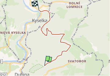
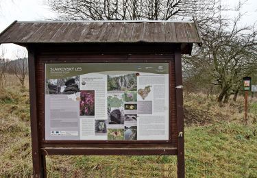
Tocht Te voet van 5 km beschikbaar op Noordwest, Regio Karlsbad, Doupovské Hradiště. Deze tocht wordt voorgesteld door SityTrail - itinéraires balisés pédestres.
Beschrijving
Tocht aangemaakt door cz:KČT.
Plaatsbepaling
Land:
Czech Republic
Regio :
Noordwest
Departement/Provincie :
Regio Karlsbad
Gemeente :
Doupovské Hradiště
Locatie:
Unknown
Vertrek:(Dec)
Vertrek:(UTM)
357605 ; 5567485 (33U) N.
Opmerkingen
Wandeltochten in de omgeving
![Tocht Te voet Pernink - NS Krušnohornická - Photo](https://media.geolcdn.com/t/375/260/7742c8b5-1539-4e34-ba2c-e0abf7ef80fe.jpeg&format=jpg&maxdim=2)
![Te voet Te voet](https://static1.geolcdn.com/sitytour/trail-icons/100.png)
NS Krušnohornická
Te voet
Gemakkelijk
Pernink,
Noordwest,
Regio Karlsbad,
Czech Republic
![](/images/other/stat-length.png)
3,6 km | 5,5 km-effort
1h 14min
![](https://static1.geolcdn.com/siteimages/upload/files/16400158638029165_repeat_loop_refresh_sync_direction_icon.png)
Neen
![Tocht Te voet Potůčky - NS Blatná - Vlčí jámy - Photo](https://media.geolcdn.com/t/375/260/fe616030-305d-41c0-9bf8-81a2ee1f178d.jpeg&format=jpg&maxdim=2)
![Te voet Te voet](https://static1.geolcdn.com/sitytour/trail-icons/100.png)
NS Blatná - Vlčí jámy
Te voet
Gemakkelijk
Potůčky,
Noordwest,
Regio Karlsbad,
Czech Republic
![](/images/other/stat-length.png)
3,2 km | 5,1 km-effort
1h 9min
![](https://static1.geolcdn.com/siteimages/upload/files/16400158638029165_repeat_loop_refresh_sync_direction_icon.png)
Ja
![Tocht Te voet Ostrov - NS Ostrovsko a hornictví - Photo](https://media.geolcdn.com/t/375/260/910090f0-4c73-4f96-889f-c4c9d6018790.jpeg&format=jpg&maxdim=2)
![Te voet Te voet](https://static1.geolcdn.com/sitytour/trail-icons/100.png)
NS Ostrovsko a hornictví
Te voet
Gemakkelijk
Ostrov,
Noordwest,
Regio Karlsbad,
Czech Republic
![](/images/other/stat-length.png)
4,5 km | 4,8 km-effort
1h 5min
![](https://static1.geolcdn.com/siteimages/upload/files/16400158638029165_repeat_loop_refresh_sync_direction_icon.png)
Neen
![Tocht Te voet Karlsbad - NS Příroda spijuje - Svatý Linhart - Photo](https://media.geolcdn.com/t/375/260/77b34aed-f1cf-47d4-ae4e-69fd5911a581.jpeg&format=jpg&maxdim=2)
![Te voet Te voet](https://static1.geolcdn.com/sitytour/trail-icons/100.png)
NS Příroda spijuje - Svatý Linhart
Te voet
Gemakkelijk
Karlsbad,
Noordwest,
Regio Karlsbad,
Czech Republic
![](/images/other/stat-length.png)
4,4 km | 5,6 km-effort
1h 16min
![](https://static1.geolcdn.com/siteimages/upload/files/16400158638029165_repeat_loop_refresh_sync_direction_icon.png)
Ja
![Tocht Te voet Ostrov - NS o koních - Photo](https://media.geolcdn.com/t/375/260/81325d62-3bd4-40cc-998e-8082c1364b9d.jpeg&format=jpg&maxdim=2)
![Te voet Te voet](https://static1.geolcdn.com/sitytour/trail-icons/100.png)
NS o koních
Te voet
Gemakkelijk
Ostrov,
Noordwest,
Regio Karlsbad,
Czech Republic
![](/images/other/stat-length.png)
3,3 km | 5,2 km-effort
1h 10min
![](https://static1.geolcdn.com/siteimages/upload/files/16400158638029165_repeat_loop_refresh_sync_direction_icon.png)
Neen
![Tocht Te voet Jáchymov - [Ž] Popov – Lanovka na Klínovec - Photo](https://media.geolcdn.com/t/375/260/162e79a2-d856-44dc-be95-d3c9e04c2a98.jpeg&format=jpg&maxdim=2)
![Te voet Te voet](https://static1.geolcdn.com/sitytour/trail-icons/100.png)
[Ž] Popov – Lanovka na Klínovec
Te voet
Gemakkelijk
Jáchymov,
Noordwest,
Regio Karlsbad,
Czech Republic
![](/images/other/stat-length.png)
7 km | 10,2 km-effort
2h 19min
![](https://static1.geolcdn.com/siteimages/upload/files/16400158638029165_repeat_loop_refresh_sync_direction_icon.png)
Neen
![Tocht Te voet Žlutice - CZ-6716 - Photo](https://media.geolcdn.com/t/375/260/c68eaa98-333f-47f8-8f76-5ea6902bcb6f.jpeg&format=jpg&maxdim=2)
![Te voet Te voet](https://static1.geolcdn.com/sitytour/trail-icons/100.png)
CZ-6716
Te voet
Gemakkelijk
Žlutice,
Noordwest,
Regio Karlsbad,
Czech Republic
![](/images/other/stat-length.png)
14,6 km | 18,7 km-effort
4h 14min
![](https://static1.geolcdn.com/siteimages/upload/files/16400158638029165_repeat_loop_refresh_sync_direction_icon.png)
Neen
![Tocht Te voet Hory - NS Doubí - Svatošské skály - Photo](https://media.geolcdn.com/t/375/260/99876ee6-f28f-404b-9743-05608e47d3ad.jpeg&format=jpg&maxdim=2)
![Te voet Te voet](https://static1.geolcdn.com/sitytour/trail-icons/100.png)
NS Doubí - Svatošské skály
Te voet
Gemakkelijk
Hory,
Noordwest,
Regio Karlsbad,
Czech Republic
![](/images/other/stat-length.png)
13,2 km | 17,3 km-effort
3h 55min
![](https://static1.geolcdn.com/siteimages/upload/files/16400158638029165_repeat_loop_refresh_sync_direction_icon.png)
Neen
![Tocht Te voet Jáchymov - naučná stezka Jáchymovské peklo - Photo](https://media.geolcdn.com/t/375/260/212b6420-01c3-4115-b8b8-7f484b00b4a3.jpeg&format=jpg&maxdim=2)
![Te voet Te voet](https://static1.geolcdn.com/sitytour/trail-icons/100.png)
naučná stezka Jáchymovské peklo
Te voet
Gemakkelijk
Jáchymov,
Noordwest,
Regio Karlsbad,
Czech Republic
![](/images/other/stat-length.png)
8,4 km | 12,9 km-effort
2h 56min
![](https://static1.geolcdn.com/siteimages/upload/files/16400158638029165_repeat_loop_refresh_sync_direction_icon.png)
Ja